Complete Guide to Wayfinding Signage: Design, Accessibility & Compliance
The Power of Wayfinding Systems
Every visitor who steps into a hospital, university, or corporate campus is on a journey.
Some come with confidence; others pause, searching for the right corridor or elevator.
When navigation feels effortless, it isn’t accidental—it’s the result of strategic wayfinding design.
The global wayfinding signage market now exceeds $3.2 billion, growing at a rate of 7.8 percent annually through 2033. Organizations are investing because clarity drives measurable results.
Research from the Society for Experiential Graphic Design (SEGD) indicates that facilities equipped with professional wayfinding systems experience a reduction of up to 60 percent in directional inquiries, 35 percent faster navigation, and a notable increase in visitor satisfaction.
BlinkSigns approaches wayfinding as both a design science and a human-centered approach.
Each sign, color, and font choice is a conversation with the user—helping them move confidently while reinforcing the brand’s identity.
What Is Wayfinding Signage?
What Is Wayfinding Signage
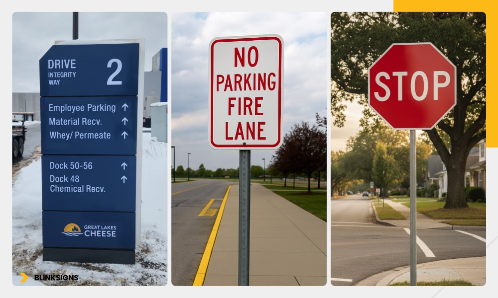
Wayfinding signage is a comprehensive visual and spatial communication system that helps people navigate through environments.
It combines text, symbols, color, and architecture to create intuitive orientation.
| Category | Primary Purpose | Typical Examples |
| Identification Signs | Label a space or destination | Room numbers, departments, restrooms |
| Directional Signs | Guide movement and route choice | Arrows to elevators, exits, and parking |
| Informational Signs | Provide helpful context | Maps, hours, building names |
| Regulatory Signs | Communicate rules or safety requirements | “No Smoking,” “Authorized Personnel Only” |
Together, these layers form the foundation of a consistent, predictable navigation experience that reduces stress and saves time.
The Psychology Behind Navigation
Effective wayfinding design begins with human perception.
People read environments before they read text, using memory, emotion, and cues such as color and landmarks.
Cognitive Mapping
Urban planner Kevin Lynch, in The Image of the City, identified five key spatial elements that help people orient themselves:
- Paths – predictable routes people follow
- Edges – boundaries or transitions between zones
- Districts – recognizable areas with shared characteristics
- Nodes – decision points where routes intersect
- Landmarks – memorable visual anchors
BlinkSigns’ designers translate these principles indoors—turning corridors into paths, wings into districts, and lobbies into nodes—so movement feels instinctive.
Color Psychology
Color evokes emotion and communicates hierarchy.
- Blues & Greens → trust & calm; perfect for healthcare.
- Oranges & Yellows → energy & creativity; suited for schools.
- Black & White Contrast → Clarity & Authority; Ideal for Corporate or Civic Facilities.
Consistency is essential: once a color system is assigned to zones, it must remain unchanged across all levels and media.
Decision Points & Viewing Distance
Users make navigation choices in seconds.
Signs positioned 3–5 feet before intersections allow enough cognitive time to act, reducing directional errors by ≈ 45 percent. Readability follows a proven rule of thumb—one inch of letter height per 25 feet of viewing distance.
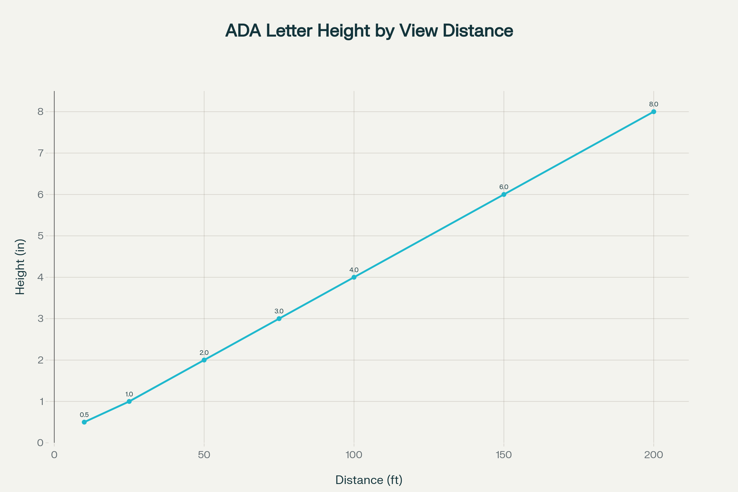
ADA letter height by view distance
Design Principles & Typography Standards
Design clarity is the language of wayfinding.
BlinkSigns adheres to evidence-based principles grounded in legibility, hierarchy, and user psychology.
1 Simplicity
Each sign should communicate a single idea.
Remove unnecessary decoration, focus on essential words, and maintain consistent iconography.
2 Typography
- Choose sans-serif typefaces such as Helvetica Neue, Frutiger, DIN, or Gotham—each proven for distance readability.
- Apply 5 to 10 percent letter spacing beyond standard body copy to prevent optical merging.
- Use mixed-case text for longer directions; all caps are effective only for short labels (e.g., EXIT).
- Avoid italics or condensed styles that reduce clarity.
3 Contrast & Lighting
Maintain a minimum contrast ratio of 70 percent between text and background.
Lighting should be even, without glare. For outdoor applications, indirect LED edge lighting improves nighttime visibility while reducing energy consumption by ≈ approximately 75 percent.
4 Hierarchy & Placement
Primary destinations (e.g., “Main Lobby”) require larger type and bold colors; secondary routes use smaller text.
Mount signage at 48–60 inches from the floor—aligned with the average eye level of both standing and seated users.
5 Consistency Across Media
Wayfinding must appear seamless across static signs, digital kiosks, printed maps, and mobile interfaces.
BlinkSigns’ design audits ensure fonts, pictograms, and arrows remain uniform throughout a property.
Material Selection & Sustainability
Materials define not only durability but also brand expression.
BlinkSigns engineers evaluate environmental exposure, traffic level, and budget before specifying substrates.
| Application | Material | Lifespan (yrs) | Key Advantages |
| Indoor | Acrylic | 10–12 | Lightweight, crisp edges, and accepts vinyl graphics well |
| Indoor/Outdoor | Aluminum | 15–20 | Corrosion-resistant, recyclable |
| High-Traffic | Stainless Steel | 25+ | Premium look, vandal-resistant |
| Outdoor Dimensional | HDU (High-Density Urethane) | 20+ | Paintable, lightweight |
| Large Exterior Panels | ACP (Aluminum Composite Panel) | 15–20 | Rigid, economical for post-and-panel systems |
Sustainable Practices
- Recycled aluminum and FSC-certified wood support LEED credits.
- Low-VOC paints reduce environmental impact.
- LED illumination provides consistent brightness with minimal energy use.
BlinkSigns’ material library strikes a balance between longevity, aesthetics, and ecological responsibility—essential for organizations pursuing green building certification.
Accessibility & ADA Compliance
Accessibility & ADA Compliance
Accessibility transforms design from attractive to inclusive.
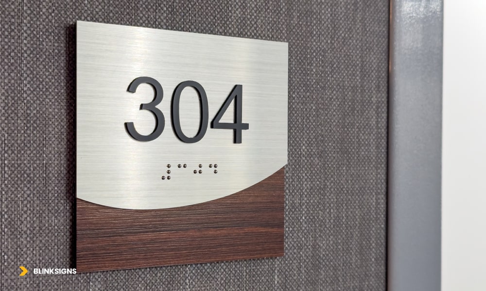
The Americans with Disabilities Act (ADA 2010) sets the minimum standards for signage that serves all users, including those with visual or cognitive impairments.
| Requirement | Specification |
| Tactile Text | Raised ≥ 1/32 in (0.8 mm); uppercase sans-serif |
| Braille | Grade 2 Braille positioned directly below text |
| Contrast | High contrast between characters and background |
| Finish | Matte or non-glare surface |
| Mounting Height | 48–60 in from floor to sign centerline |
| Character Size | ⅝ – 2 in, depending on viewing distance |
Beyond Compliance: Universal Design
Universal design ensures accessibility for everyone, not only those protected by law.
- Cognitive Accessibility: Use clear icons (ISO 7001 pictograms) and concise language to enhance accessibility.
- Tactile Cues: Include raised lettering and directional arrows that users can feel.
- Audio Support: Bluetooth Low Energy (BLE) beacons can trigger spoken directions on smartphones
- Color-Blind Safety: Test palettes with digital contrast analyzers to avoid confusion with red-green color pairs.
- Wayfinding for Neurodiverse Users: Consistent Icon Shapes Reduce Cognitive Load.
Common ADA Mistakes
- Mounting height is measured from the bottom, not from the centerline of the device.
- Braille is placed beside the text rather than below it.
- Glossy surfaces create glare.
- Text obstructed by doors or decorative elements.
BlinkSigns conducts on-site ADA audits and uses digital luminance-contrast testing to guarantee each installation meets and documents full compliance.
The Value of Universal Accessibility
Inclusive signage benefits every visitor—not just those with disabilities.
A parent pushing a stroller, an employee carrying equipment, or an international traveler reading in a second language—all rely on intuitive design.
Organizations that adopt universal design principles not only avoid litigation but also strengthen brand equity.
Accessibility communicates care, competence, and trust—the cornerstones of a positive visitor experience.
Clarity is comfort.

BlinkSigns designs and fabricates ADA-compliant, universally accessible wayfinding systems that help everyone reach their destination—confidently, safely, and on brand.

Learn More About Our ADA Signage Solutions →
Digital Integration, Industry Applications & ROI
Digital Integration, Industry Applications & ROI
The Digital Evolution of Wayfinding
The past decade has redefined how people navigate large or complex environments.
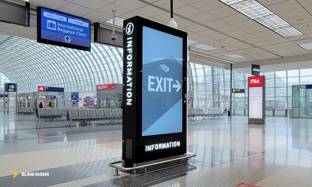
Smartphones, touchscreens, and IoT sensors have transformed signage from static communication into interactive guidance ecosystems.
Digital wayfinding bridges architecture and technology.
It offers real-time route updates, supports multiple languages, and collects analytics that inform better space planning.
Hospitals monitor patient flow, universities study campus traffic, and corporations analyze visitor movement—all through data gathered from digital signage systems.
Hybrid systems, which combine physical and digital elements, are now the industry standard.
They unite the trust of static signage with the flexibility of digital displays and personalization of mobile maps, creating consistent navigation experiences across every touchpoint.
| Component | Primary Function | Common Example |
| Static Signage | Permanent guidance and branding | Directional, ADA, identification signs |
| Interactive Displays | Real-time maps, announcements | Lobby kiosks, hospital directories |
| Mobile Wayfinding Apps | Personalized routes on phones | QR-linked maps on campuses |
| Indoor Positioning Systems (IPS) | Real-time location tracking | Bluetooth or Wi-Fi beacon networks |
When implemented strategically, digital integration simultaneously strengthens brand image, accessibility, and operational efficiency.
Implementing a Modern Wayfinding Program
A successful wayfinding project requires more than fabrication.
It requires a structured approach that blends design, engineering, and stakeholder collaboration.
BlinkSigns utilizes a five-phase implementation framework that has been proven to deliver consistent results.
- Audit & Journey Mapping
Evaluate existing layouts, pain points, and user behaviors to identify areas for improvement. Identify “decision nodes” where visitors require direction.
- Design & Prototyping
Develop CAD-based placement maps and visual mock-ups. Validate legibility, lighting, and ADA compliance through digital previews.
- Fabrication
Produce signs using UV-resistant materials and low-VOC inks in controlled facilities for precision and sustainability.
- Installation
Coordinate with facility teams to ensure safe mounting, accurate alignment, and power integration for digital components.
- Testing & Training
Conduct on-site verification, contrast tests, and CMS training for staff who will maintain or update digital content.
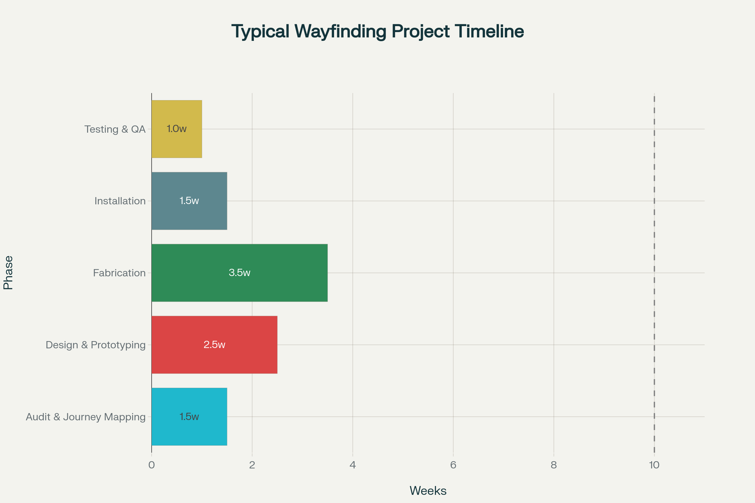
Typical wayfinding project timeline chart
BlinkSigns’ project management system tracks each phase from discovery to delivery, ensuring compliance, accountability, and transparent communication.
Digital Technologies Transforming Navigation
1 — Interactive Kiosk Systems
Large-format touchscreen kiosks (32–65 inches) serve as intuitive hubs where users can search destinations, preview routes, and print or scan QR codes for mobile navigation.
Key Features
- 3D maps with pinch-to-zoom and rotation
- Voice-guided and high-contrast accessibility modes
- Multi-language interface for global visitors
- Live event scheduling and emergency alerts
- Real-time content updates through cloud-based CMS
Implementation Tips
- Place kiosks at high-traffic nodes (entrances, elevator lobbies).
- Standardize screen heights to meet ADA reach ranges (48–54 in).
- Assign content managers with defined approval workflows.
- Clean and recalibrate screens quarterly.
Typical investment: $8,000–$25,000 per kiosk, including installation and first-year service.
2 — Augmented Reality (AR) Wayfinding
AR overlays digital arrows and labels onto the physical environment using smartphone cameras.
Users simply scan their surroundings and follow floating guidance cues.
Core Technology
- Computer Vision & SLAM (Simultaneous Localization and Mapping) track device position in 3D space.
- Wi-Fi RTT or Bluetooth Beacons provide positional accuracy within 1–3 meters.
- Cloud Map Databases store layouts and dynamically trigger overlays.
Real-World Use
- Hospitals, including the Cleveland Clinic and Mayo Clinic, pilot AR for patient navigation.
- Airports: Helsinki and LAX integrate AR to reduce missed-gate incidents.
- Universities: Arizona State University employs AR for orientation tours.
ROI Impact
Although setup costs range from $50,000 to $200,000, AR cuts directional inquiries by up to 70% and eliminates recurring reprint expenses for map updates.
3 — Indoor Positioning Systems (IPS)
IPS solutions bring GPS-like precision indoors.
Three major technologies dominate:
| Technology | Infrastructure | Accuracy | Best For |
| Bluetooth Low Energy (BLE) | Battery beacons every 30–50 ft | 1–3 m | Retail, museums, events |
| Wi-Fi RTT (Round Trip Time) | Existing routers | 1–2 m | Offices, campuses |
| Ultra-Wideband (UWB) | Specialized anchors | 10–30 cm | Healthcare, logistics |
IPS analytics reveal dwell times, bottlenecks, and unused areas—data invaluable for facility optimization and brand engagement measurement.
Integration with Building Systems
Accurate digital wayfinding doesn’t operate in isolation.
It synchronizes with existing facility infrastructure to streamline management and enhance visitor experience.
- Building Management Systems (BMS): Display room availability and temperature controls in real time.
- Event Scheduling Software: Automatically update meeting or classroom locations.
- Emergency Protocols: Override standard navigation during evacuations.
- Parking Guidance Systems: Direct vehicles to available parking spaces and link to pedestrian maps.
- Visitor Management Platforms: Generate custom QR maps for pre-registered guests.
BlinkSigns’ integration specialists ensure interoperability between signage CMS platforms and enterprise systems—reducing redundancy and operational friction.
ROI and Cost Efficiency
Investing in professional wayfinding is not an expense; it’s a measurable performance strategy.
Facilities that modernize their navigation systems see tangible reductions in confusion, staff time, and missed appointments.
Operational Savings
- Before Implementation: 185 inquiries/day × 3 min each = 9.25 staff hours lost.
- After Implementation: 92 inquiries/day = 4.6 hours lost.
- Annual Savings: ≈ $30,000 in reclaimed labor time.
Performance Impact
- 39 % faster average navigation
- 44 % higher visitor satisfaction scores
- 50 % reduction in staff assistance requests
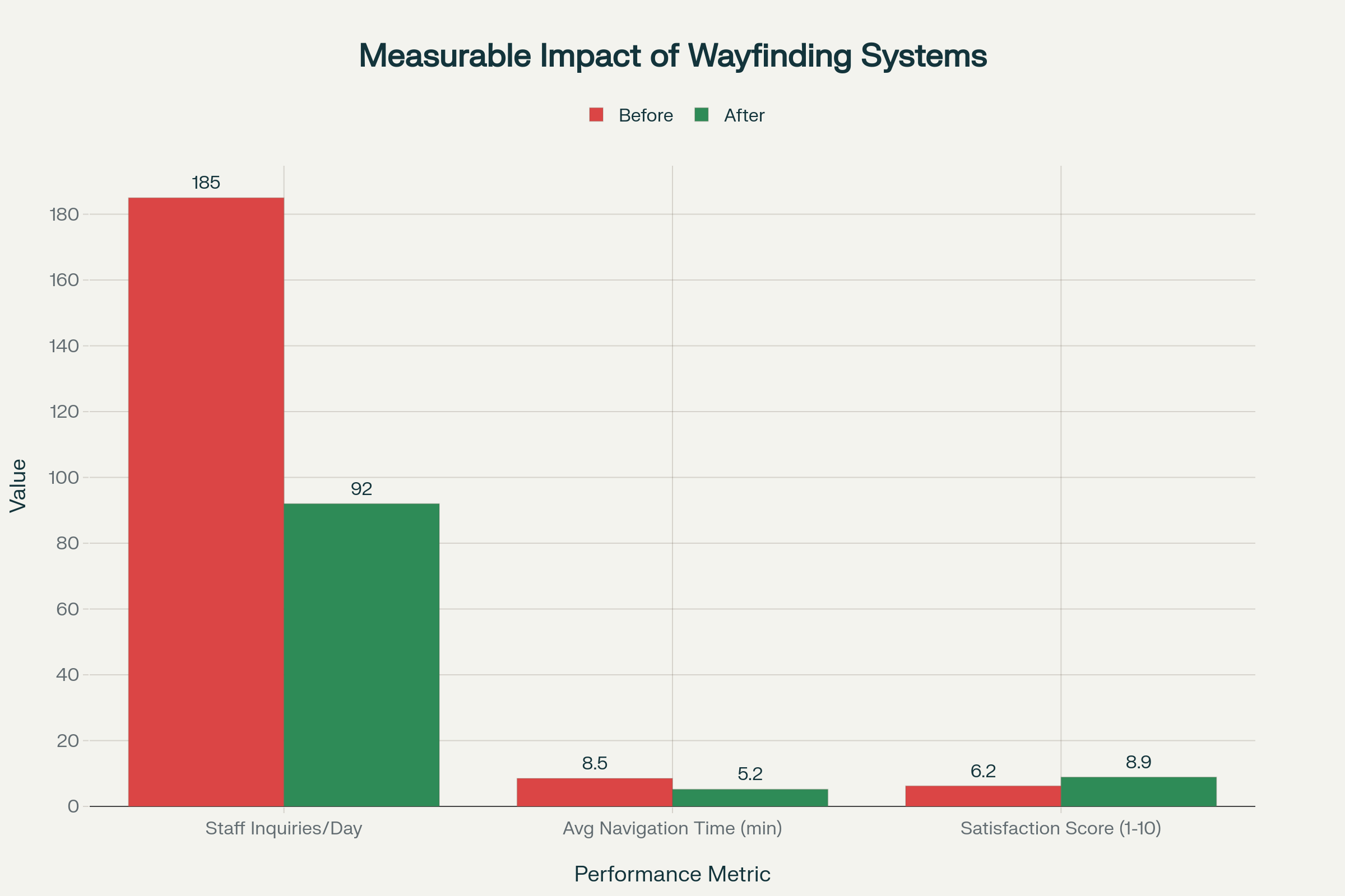
Measurable Impact of Wayfinding Systems
Five-Year Cost Comparison
A long-term perspective reveals why digital investments consistently outperform static systems in terms of value creation.
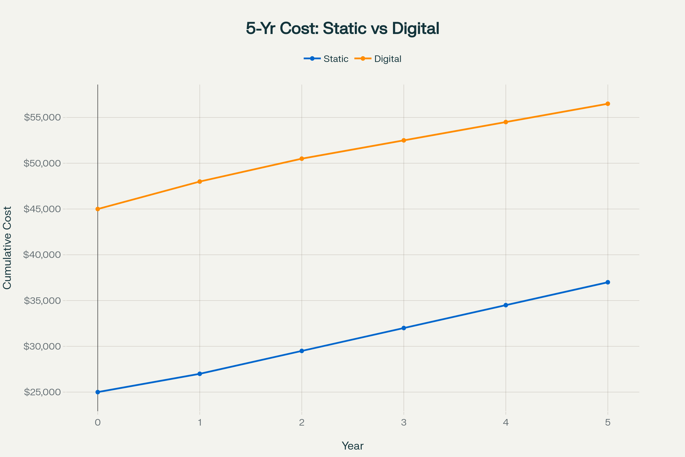
5-Year Cost Comparison — Static vs Digital
Despite higher upfront costs, digital systems yield more substantial ROI through analytics, remote updates, and advertising potential.
Most organizations reach payback in 18–24 months.
Industry-Specific Applications
Healthcare Facilities
Hospitals often feature multi-wing complexes, high stress levels, and constant layout changes.
Professional wayfinding minimizes anxiety and enhances safety.
- Color-coded floor zones (e.g., Blue Wing = Cardiology).
- Reassurance graphics (“You’re Almost There”) to calm patients.
- Antimicrobial vinyl and sealed edges for infection control.
- Multilingual signage and Braille for diverse demographics.
Case Insight
BlinkSigns partnered with a leading Urgent Care provider to design and implement a streamlined signage program that improved patient flow and brand consistency across multiple clinic locations.
The scope included high-visibility channel letters for exterior identity, intuitive wayfinding and directional signage for quick navigation, and digital signage to support real-time communication and patient updates.
With a focus on clarity, compliance, and fast-paced healthcare environments, BlinkSigns delivered a fully integrated solution that enhances accessibility, reduces wait-area confusion, and reinforces a trusted care experience from entry to discharge.
Educational Campuses
Universities require adaptable systems for seasonal events and frequent relocations.
Solutions
- QR-enabled digital directories for real-time updates.
- Temporary banners for orientation or graduation.
- Landmark-based navigation (“Turn left at the Clock Tower”).
- Emergency protocol integration via mobile alerts.
The result: reduced confusion for first-year students and improved event flow across large campuses.
Corporate Environments
Corporate offices blend brand identity with functionality.
Wayfinding extends that branding into spatial design.
Features
- Branded color palettes and materials.
- Modular tenant directories for flexible leasing.
- Parking-to-desk navigation connecting garages to suites.
- Pre-arrival QR codes linking visitors to meeting-room directions.
Straightforward internal navigation enhances professionalism and leaves a positive first impression with clients and partners.
Retail & Mixed-Use Developments
Retail complexes rely on signage to encourage exploration and repeat visits.
Key Elements
- Digital tenant directories with real-time updates.
- Promotional overlays highlighting new stores or seasonal events.
- Level identifiers and “parking memory” features for multi-story malls.
- Data-driven advertising placements on digital screens.
Smart navigation has a direct impact on dwell time and purchase intent, converting efficient movement into measurable sales.
FAQ
Q1. What is the difference between wayfinding and regular signage?
Regular signage labels locations; wayfinding connects the entire journey through a coordinated system of identification, directional, informational, and regulatory layers.
Q2. How long does wayfinding signage last?
Indoor systems = 10–15 years; outdoor aluminum = 15–20 years; digital hardware refresh = every 5–7 years.
Q3. Which materials work best outdoors?
Powder-coated aluminum and HDU panels, paired with 3M or Avery Dennison UV vinyl, offer maximum durability.
Q4. Do I need permits for wayfinding signage?
Exterior signs typically require building permits, while interior signs must comply with fire and ADA codes.
Q5. How do I maintain ADA compliance after updates?
Any new or modified sign must meet ADA 2010 standards. Perform annual audits and retain documentation.
Q6. What’s the average cost per sign?
Typically $150–$800 depending on size, materials, and complexity. System-level pricing averages $300 to $600 per installed sign.
Q7. What’s included in a comprehensive system budget?
Design, site survey, engineering, fabrication, installation, and project management — often 40–60 % beyond fabrication alone.
Q8. How often should digital content be updated?
At least quarterly for accuracy; event-driven facilities may require weekly refreshes.
Q9. Can digital and static signage coexist?
Yes. Hybrid systems offer the best balance of permanence and flexibility.
Q10. How does analytics enhance ROI?
Visitor flow data helps optimize sign placement and content, reducing confusion and improving resource allocation.
Navigation That Builds Trust
When people move confidently through a space, they feel a sense of belonging there.
That emotional assurance is the unseen value of a professional wayfinding approach.
By combining clear design, ADA compliance, and digital innovation, BlinkSigns helps organizations transform complex environments into intuitive experiences.
Every successful journey, whether it guides a patient to radiology, a student to class, or a shopper to a new store, strengthens brand credibility.
Ready to simplify navigation and enhance your visitor experience?
Request a Free Wayfinding Assessment →